Талаада тоолуу аймактарда шлюздарды орнотуу боюнча көйгөйлөр айтылат

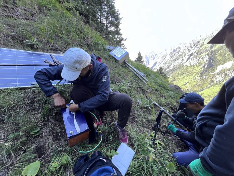
Climbing 700 meters with a 55° slope with solar panels, heavy batteries, and an IoT communication gateway strapped to our backs is not the usual picture of innovation and one wouldn’t think of AI in such context. However, this was exactly what it took to bring climate monitoring communication network to one of the most remote and high altitude places on Earth.

Recently, our team completed the installation of an IoT communication gateway near the Kara-Batkak (3360-4800 altitude) and Aylama glaciers in the Terskey-Alatoo mountain range. This system will connect affordable climate-related sensors at high altitudes — places where critical data is still missing not only in Kyrgyzstan or Third Pole, but globally.

Most foundational climate AI models today rely on assumptions to fill in gaps (cdf-mapping, bias-correction, etc), because the ground data from mountainous regions simply doesn’t exist. The cryosphere — glaciers, snow, and permafrost — remains under-observed, under-researched particularly in the world’s high mountain ranges. The Third Pole Regional Climate Center reported that in the entire Pan-Third Pole region, only 28 monitoring stations sat above 3000 meters out of nearly 700. These are exactly the altitudes where some of the most dramatic changes are taking place.

And the stakes are high. According to ICIMOD even in a world that warms by just 1.5 to 2°C, glaciers in the Third Pole could lose 30 to 50 percent of their volume by the end of this century. Without precise, high-resolution data, real-time data, AI models risk underestimating the hazards we face, from permafrost instability and glacier detachments to glacial lake outburst floods and snow droughts.

That is why Precision matters! Even down to the third-fourth decimal place, every data point helps improve forecasts, anticipate risks, and strengthen climate models that inform policy and adaptation strategies.

The summertime is high season for field works and installations far from the digital sphere in unconnected areas trying to connect the last-mile and secure supply of high precision data for scientists and local communities. For me, the climb was exhausting, but also deeply meaningful. Just like other teammates, I’ve suffered from pain, exhaustion, walking/falling through slippery meadows… Right there in altitude of 3000, looking into the downstream rivers, with spectacular views around, it was a reminder to me that innovation doesn’t only happen in labs, conference rooms, or algorithms. Sometimes it begins with sweat, altitude, and determination — carrying heavy equipment up a mountain so that the world can better understand what is at stake. And it was the second from 15 installations planned under the research project funded by the Internet Society Foundation and implemented by the Internet Society Kyrgyz Chapter along with partners.

Lorem ipsum dolor sit amet, consectetur adipiscing elit. Ut elit tellus, luctus nec ullamcorper mattis, pulvinar dapibus leo.

From Mountains to Data – Insights from RIPE 89

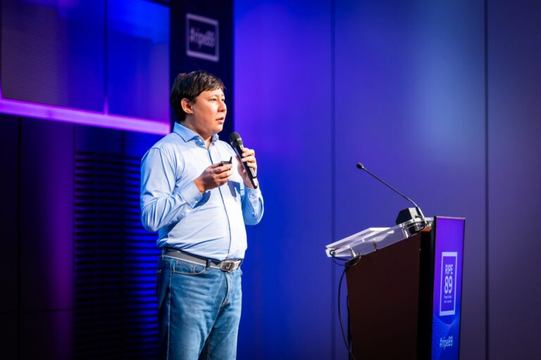
The RIPE 89 Meeting, held in Prague, brought together a vibrant mix of technology enthusiasts and industry experts to share knowledge on data, networking, and innovation. Organized by the RIPE Network Coordination Centre (RIPE NCC), this annual gathering serves as a crucial forum for fostering collaboration and exchanging ideas within the global internet community. One of the standout sessions was “From Mountains to Data,” presented by Aziz Soltobaev under the RIPE Academic Cooperation Initiative (RACI). This talk illustrated the journey of turning raw natural data into valuable digital insights.

In his presentation, Aziz Soltobaev discussed how immense, raw data sourced from the natural world can be transformed into actionable information. This theme transcends theoretical discussion and dives into practical solutions for collecting, managing, and analyzing vast environmental data sets. The metaphor of mountains symbolized both the physical challenge of remote data collection and the inherent complexity of processing unrefined data.

In his presentation at RIPE 89, Aziz Soltobaev emphasized the challenges of data collection in Kyrgyzstan’s mountainous regions, stating, “Deploying sensors in these remote areas is not just about technology; it’s about overcoming logistical hurdles and ensuring data reliability.”

Key Insights and Technological Challenges

Data Collection in Remote Areas: Soltobaev highlighted the difficulties encountered when gathering data in rugged, mountainous regions. Deploying sensors, ensuring reliable data transmission, and dealing with extreme conditions demand both creative problem-solving and technological ingenuity.
Advanced Data Processing: After collection, raw data must be processed to uncover valuable insights. Soltobaev underscored the importance of powerful computational tools like machine learning algorithms and high-performance computing to effectively analyze and interpret this data.
Transforming Data into Decisions: The ultimate aim of this data transformation is to support informed decision-making in areas such as environmental preservation, urban development, and disaster preparedness. Soltobaev provided examples where analyzed data was used to predict natural events and assess their potential impact on communities. “By transforming raw environmental data into actionable insights, we can make informed decisions in urban planning and disaster preparedness, ultimately benefiting our communities”, Aziz said.

Relevance for Networking and Technology Experts
This topic holds significant relevance for the RIPE community. Soltobaev’s insights highlighted parallels between challenges in environmental data handling and the complexities of managing global network infrastructures. Both require scalable, resilient systems capable of adapting to varied and sometimes overwhelming data demands.

Future Perspectives
The presentation “From Mountains to Data” underscored a broader message: the convergence of data, technology, and environmental understanding can lead to innovative, cross-disciplinary solutions. By tackling complex data with the right tools and methodologies, what once seemed insurmountable can be turned into actionable knowledge that benefits multiple sectors.

This session at RIPE 89 emphasized that, with determination and the right technological strategies, even the most challenging data can be harnessed to pave the way for smarter, data-driven decision-making across environmental and technical landscapes.

Additional links:

  • https://ripe89.ripe.net/programme/meeting-plan/iot-wg/
  • https://ripe89.ripe.net/programme/blog/
  • https://ripe89.ripe.net/archives/video/1476/

From Mountains to Data Low-Cost Weather Stations in Kyrgyzstan’s Challenging Terrain

On behalf of the research team, I am very pleased to announce that our preprint of a research paper on the use of low-cost automatic weather stations, LoRaWAN technology and various IoT sensors has been published. “From Mountains to Data: Low-Cost Weather Stations in Challenging Conditions in Kyrgyzstan” describes the selection criteria for the equipment to be deployed and provides detailed information on the installation process at the pilot sites, as well as the challenges encountered during the project.

For me, one of the main conclusions of this research project is that there has been a significant breakthrough in the quality and availability of telemetry sensors over the past five years.

Our data analysis shows that two-tier automatic weather stations demonstrate similar results (daily, decadal, monthly averages) with a high degree of accuracy (95-98%) as the first-tier AWS. The only difference is that new technologies have reduced the cost of weather stations by 10-20 times. Instead of $50,000 worth of equipment, you can use $1,000-$5,000 weather stations and get identical results (subject to regular calibration and maintenance of the equipment).

The second important takeaway is the demonstration of the potential of LoRaWAN data transmission technology for rapid deployment and monitoring of climate change, creation of geoinformation models, forecasting future trends, and taking mitigating preventive measures.

The third important takeaway is the practical application of such an approach to data transmission as Delay-Tolerant Networks. With this approach, under adverse external conditions, data can be collected and transmitted later. In the conditions of the pilot project in Kyrgyzstan, DTN showed good performance in severe frost conditions in December 2023, when the temperature dropped to -23-28 degrees. As a result, some nearby cell towers were disconnected for a while, as were some of our sensors. However, data recording continued, and when the network was restored, the data was successfully transmitted to the central server.

The full version of this article will be published in the next issue of the scientific journal Sensors. This scientific work became possible during the implementation of the research project of the Internet Society Kyrgyz Chapter with the financial support of the Internet Society Foundation.

Жалал-Абад облусундагы жер көчкүлөрдү чалгындоо

The initial deployment of a LoRa-enabled network to monitor natural disasters such as landslides and mudflows holds considerable promise. In response to positive feedback and a request from the Ministry of Emergency Situations, the ISOC team embarked on a journey to the southern region of Kyrgyzstan to assess potential pilot locations.

During the first weeks of December, the team visited two active landslides located in Jalal-Abad Oblasty of the republic. The first landslide is situated in Karamart (Kara-Mart), Suzak Rayon.

According to the Department of Monitoring of Natural Disasters under the Ministry of Emergency Situations, there is a high risk of landslide activation on the right bank of the river Kök-Art, in lateral valleys of Achy-Say, Karamart, and on the slopes between the Karamart, Urum-Bashy, and Kök-Art rivers.

The second location is a landslide near the village of Kichi-Ak-Jol in Suzak Rayon, along the strategic road connecting the region with the highway leading to Bishkek and Osh cities.

The reconnaissance was conducted using drones, topographic video, and photography. Initial contacts with local administration were established during this phase.

The gathered information will undergo thorough review and analysis, and a LoRa-enabled topology network will be proposed to effectively monitor and respond to these landslide-prone areas.

Илим жана туруктуу өнүгүү үчүн экстремалдык шарттарда байланыш боюнча семинар

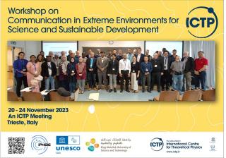
On November 2023 we had a privilege to participate in the Workshop on Communication in Extreme Environments for Science and Sustainable Development held in Trieste, Italy. The workshop had been organized by our partner organization Abdus Salam International Centre for Theoretical Physics (ICTP). The workshop brought together researchers and practitioners who shared insights and expertise on building sustainable communication networks, use of low power internet of things as well as learning advanced technologies and protocols for connecting unconnected. We have explored how 6G networks, new forms of sattelite connectivity, non-terrestrial networks and underground communications could help connect the unconnected. The Days of Delay Tolerant Network and Lora mesh Labs helped to gain practical skills and learn new tools to consider in the future communication projects.

We as Internet Society Kyrgyz Chapter shared our experience on using Internet of Things and LoRaWAN technologies for climate monitoring and early warning in mountainous areas. This 2-year project aimed to explore how LoRaWAN and Lora-enabled devices in conjuction with open source solutions could be utilized in extreme climate conditions, mountainous areas to monitor such natural disasters as mudflows, landslides, glacier lake outburst floods and help relevant decision makers to take mitigation actions.

Kyrgyz Republic has over 4000 lakes mostly caused by glaciers and located in altitude between 2500 and 4000 meters. Currently, there are about 5000 active landslides registered in the country. Over the last 30 years 593 landslide disaster events were recorded in Kyrgyzstan.

Our research project is funded by the Internet Society Foundation research grants component.

LoRawanCentralAsia climateresilience climatetech sustainabletech internetofthings 6GCentralAsia #spacecommunicationskyrgyzstan

Адыгене көлүнүн пилоттук жеринде орнотуу иштери аяктады

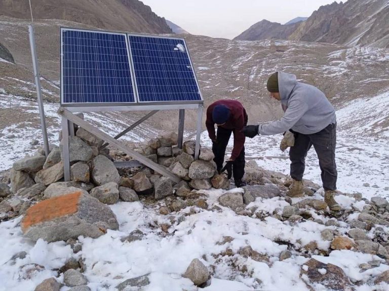
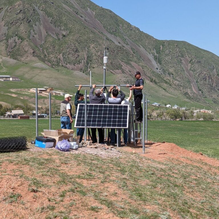
The review of installation works conducted on August and feedback from the installation team revealed that proposed scheme was not sustainable to weather conditions in the altitude of 3600m.

Based on consultations with the experts from CAIAG, Institute of Water Problems as well as ICTP, some changes had been proposed in carcass of the composition to keep photovoltaics as well as its location.

The installation team moved the structure from one hill to another, conducted welding and strengthening works on Adygene high mountain glacial lake.

Due to the delayed installation works, the research team were unable to setup Lorawan gateway and sensors this year. The cold weather conditions and expedition difficulties. We hope to finalize work by May, 2024.

Installation works on Adygene lake pilot location completed

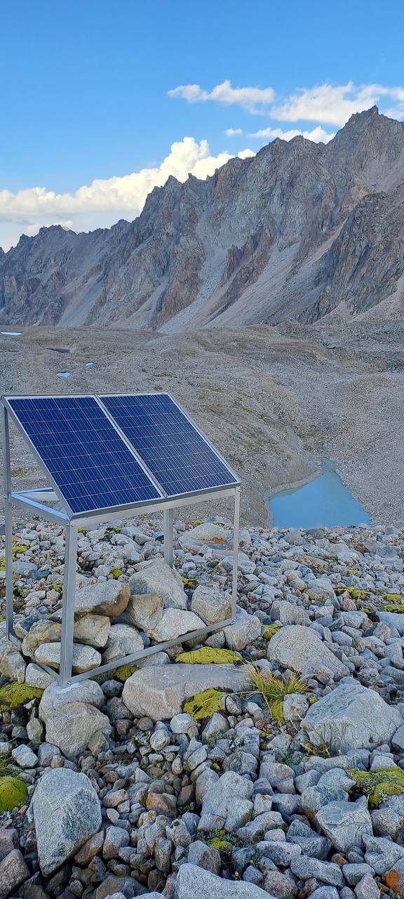
The construction team had built masts, photovoltaics on established locations on Adygene lake.

A month ago, the joint research team had visited high glacier mountain lake, collected initial data. The desk analysis of the data showed that there are some spots that could be feasible for establishing connection between lora-enabled devices and nearest cellular tower located in a distance of about 25 and 40km from the lake in Chuy valley.

Considering that pilot location is located in high altitudes, where harsh winter conditions and regularly windy, the team built design of construction masts and tower.

The construction team prepared all ready-to-built parts and materials, carried all materials on foot to the base and finished construction of tower and solar panel for the communication device as well as towers for environment monitoring internet of things.

We expect to setup and connect it on September, 2023.

Кыргызстандагы Lora картасы

In a pioneering initiative, the Internet Society Kyrgyz Chapter has embarked on a groundbreaking project to test and map LoRa-enabled gateway coverage in select pilot locations. This endeavor marks a significant leap forward in the realm of Internet of Things (IoT) technology, aiming to enhance connectivity, streamline data collection, and fortify research efforts.

Mapping LoRa-enabled gateway coverage is a crucial step in advancing IoT infrastructure of the country. LoRa (Long Range) technology, known for its extended range and low power consumption, is increasingly employed in diverse applications, including environmental monitoring, agriculture, and smart city solutions. The success of these applications relies heavily on the optimal placement and coverage of LoRa gateways.

The process of mapping LoRa-enabled gateway coverage involves a meticulous survey of the targeted area, considering topography, geographical features, and potential interference. The ISOC Kyrgyz Chapter, in collaboration with local partners, is employing cutting-edge techniques to identify strategic locations for LoRa gateways. These gateways serve as crucial communication hubs, facilitating the seamless transfer of data between IoT devices and the central network.

The benefits of mapping LoRa-enabled gateway coverage are manifold. Firstly, it ensures that IoT devices within the coverage area can efficiently communicate with the network, enabling real-time data transmission. This is particularly vital for research initiatives focused on environmental monitoring, where timely and accurate data is imperative for informed decision-making.

Secondly, the strategic placement of LoRa gateways optimizes network efficiency, reducing the chances of signal interference and packet loss. This, in turn, enhances the reliability and stability of IoT applications, making them more robust in challenging environments.

From a research perspective, the mapped data provides valuable insights into the performance and limitations of LoRa technology in specific geographic contexts. Researchers can analyze coverage patterns, identify potential dead zones, and fine-tune gateway placements for maximum efficacy. This iterative process of testing and mapping contributes to the continuous improvement of IoT infrastructure, fostering innovation and advancements in diverse fields.

In conclusion, the ISOC Kyrgyz Chapter’s initiative to test and map LoRa-enabled gateway coverage in pilot locations is a commendable stride towards harnessing the full potential of IoT technology. By strategically placing gateways and optimizing coverage, this effort not only enhances connectivity and data reliability but also lays the groundwork for transformative research endeavors that leverage the power of the Internet of Things for natural disaster monitoring and prediction.

Бийик тоолуу Адыгене көлүнө илимий саякат

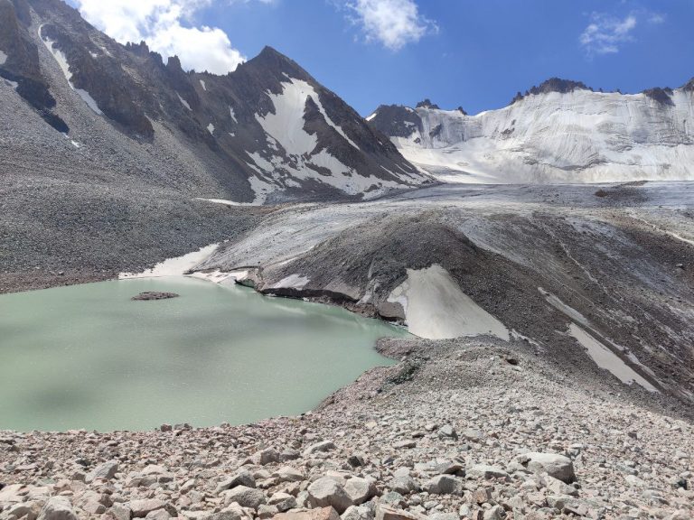
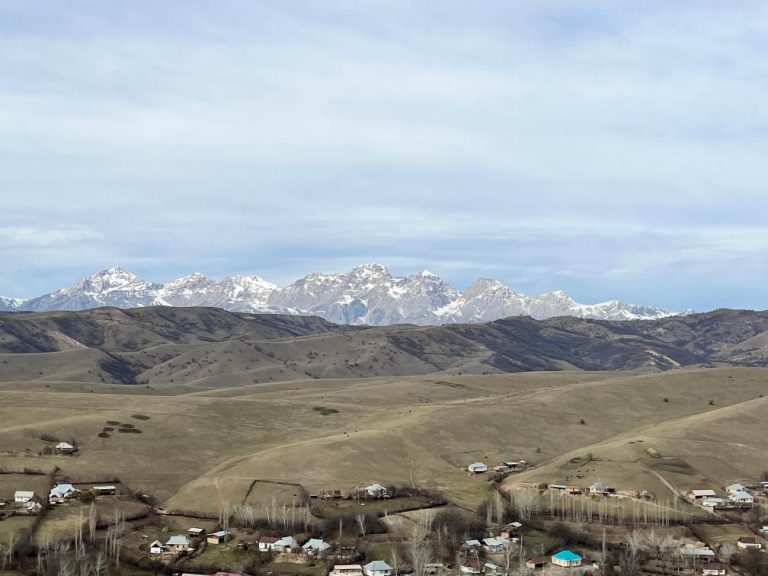
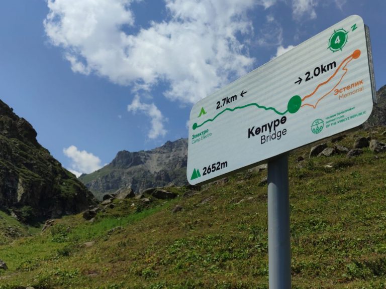
On July 21, the ISOC research team embarked on an expedition to Adygene Glacier Mountain Lake, strategically situated 60 km south-southwest of Bishkek. Nestled at an altitude of 3600m in the upper reaches of the Adygene river valley, a left-side tributary of the Ala-Archa river, this high glacier lake serves as a focal point for the deployment of IoT sensors aimed at monitoring glacial lake outburst floods.

The Adygene lake complex, positioned on the sea of the glacier, encompasses three additional lakes to the south and southeast. The southeasternmost lake, situated at an elevation of 3640 meters, was formed along the northern edge of the glacier, with its southern coast adjoined to the glacier itself. Measuring 188 meters in length and 70 meters at its widest point, the lake has a perimeter of 550 meters, covering an area of 17142 square meters. A stream flows from the northeastern side, eventually merging with a small moraine lake after a 330-meter journey. Additionally, the southern part of the lake houses ten more small moraine lakes.

Under the guidance of our partner, the Institute of Water Problems under the Academy of Sciences of the Kyrgyz Republic, Adygene glacier lake has been subject to monitoring using various technological means. The Adygene station, established in 2008, plays a pivotal role in studying high mountain lakes and glaciers while safeguarding the local population from potential outbursts. Adjacent to the station, a traditional meteorological station has been set up, where researchers manually collect daily data using sensors and retrieve information from an automatic station.

Initially, geostationary connectivity was employed due to the absence of mobile coverage. However, owing to budgetary constraints, this option was abandoned, given the exorbitant monthly costs ranging from 200 to 500 USD.

Recognizing the line of sight with Chuy valley base stations, the Research team of ISOC Kyrgyz Chapter and ICTP proposed the implementation of LoRaWAN connectivity, offering real-time 24/7 monitoring at a more affordable 3-dollar GSM connectivity monthly plan.

With this strategic rationale, the ISOC Kyrgyz Chapter members and interns from the Institute of Water Problems embarked on a strenuous six-hour hike to the location. The journey was characterized by challenging terrain, transitioning from hot summer conditions to rainy and windy weather, accompanied by temperature fluctuations of up to 20 degrees.

Upon reaching the destination, the team meticulously assessed connectivity, identified potential spots for setting up communication gateways, determined the types of measurements and sensors required, and outlined the necessary mast installations. Following an intense day, the team returned to the main road of Ala-Archa national park late at night. Armed with the collected data, a comprehensive working and logistics plan was formulated for the installation of the Internet of Things infrastructure at Adygene Glacier Lake.