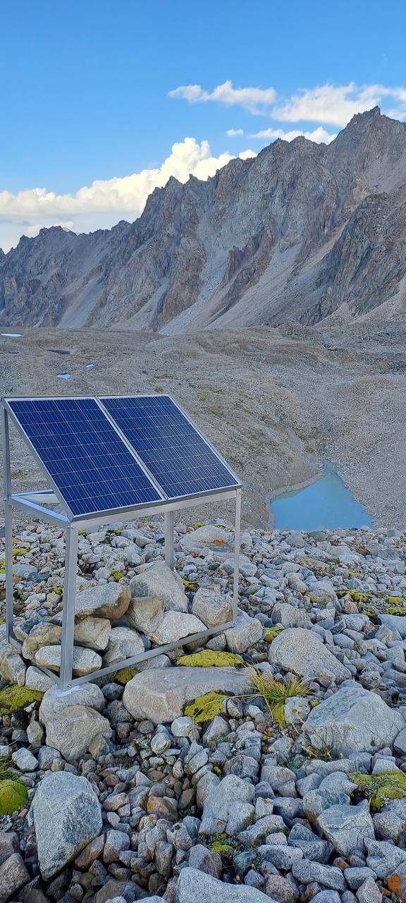
Адыгене көлүнүн пилоттук жеринде орнотуу иштери аяктады

The review of installation works conducted on August and feedback from the installation team revealed that proposed scheme was not sustainable to weather conditions in the altitude of 3600m.

Based on consultations with the experts from CAIAG, Institute of Water Problems as well as ICTP, some changes had been proposed in carcass of the composition to keep photovoltaics as well as its location.

The installation team moved the structure from one hill to another, conducted welding and strengthening works on Adygene high mountain glacial lake.

Due to the delayed installation works, the research team were unable to setup Lorawan gateway and sensors this year. The cold weather conditions and expedition difficulties. We hope to finalize work by May, 2024.

Installation works on Adygene lake pilot location completed

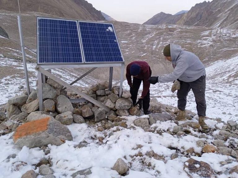
The construction team had built masts, photovoltaics on established locations on Adygene lake.

A month ago, the joint research team had visited high glacier mountain lake, collected initial data. The desk analysis of the data showed that there are some spots that could be feasible for establishing connection between lora-enabled devices and nearest cellular tower located in a distance of about 25 and 40km from the lake in Chuy valley.

Considering that pilot location is located in high altitudes, where harsh winter conditions and regularly windy, the team built design of construction masts and tower.

The construction team prepared all ready-to-built parts and materials, carried all materials on foot to the base and finished construction of tower and solar panel for the communication device as well as towers for environment monitoring internet of things.

We expect to setup and connect it on September, 2023.

Partnering with Ilbirs Foundation

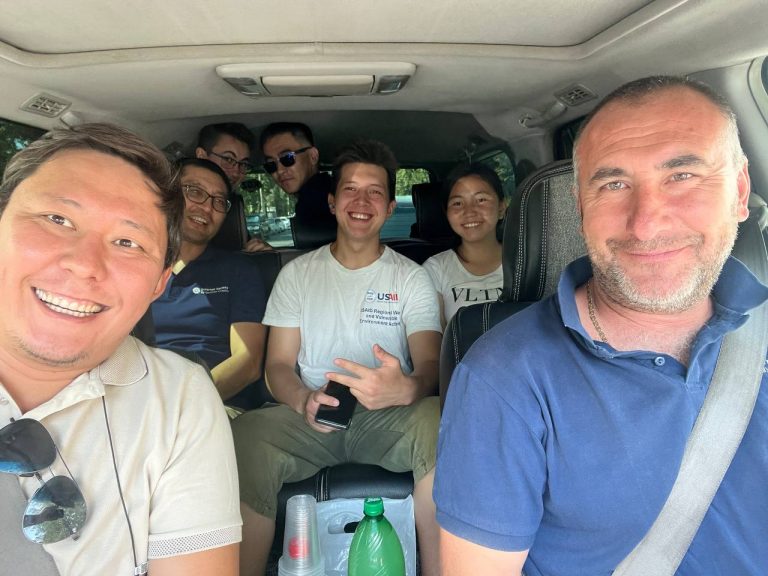
On August 11, 2023, ISOC Kyrgyzstan Chapter – Aziz Soltobaev and Talant Sultanov – teamed up with representatives from the Ilbirs Foundation and SMART consultant Michael Hotte for a crucial meeting about protecting nature and wildlife.
The main decision from their discussion was to use Lorawan technology for better wildlife monitoring. This advanced technology can transmit data even in places without cell service, making it easier to react quickly to environmental changes.
We proposed to consider use of lora-enabled devices with machine learning tools to use as camera traps as well as to fight poachers. We hope to find innovative solutions to enable Ilbirs Foundation with practical technological solutions to reach their mission: keeping nature safe and ensuring a better, safer future.
ilbirs foundation

Кыргызстандагы Lora картасы

In a pioneering initiative, the Internet Society Kyrgyz Chapter has embarked on a groundbreaking project to test and map LoRa-enabled gateway coverage in select pilot locations. This endeavor marks a significant leap forward in the realm of Internet of Things (IoT) technology, aiming to enhance connectivity, streamline data collection, and fortify research efforts.

Mapping LoRa-enabled gateway coverage is a crucial step in advancing IoT infrastructure of the country. LoRa (Long Range) technology, known for its extended range and low power consumption, is increasingly employed in diverse applications, including environmental monitoring, agriculture, and smart city solutions. The success of these applications relies heavily on the optimal placement and coverage of LoRa gateways.

The process of mapping LoRa-enabled gateway coverage involves a meticulous survey of the targeted area, considering topography, geographical features, and potential interference. The ISOC Kyrgyz Chapter, in collaboration with local partners, is employing cutting-edge techniques to identify strategic locations for LoRa gateways. These gateways serve as crucial communication hubs, facilitating the seamless transfer of data between IoT devices and the central network.

The benefits of mapping LoRa-enabled gateway coverage are manifold. Firstly, it ensures that IoT devices within the coverage area can efficiently communicate with the network, enabling real-time data transmission. This is particularly vital for research initiatives focused on environmental monitoring, where timely and accurate data is imperative for informed decision-making.

Secondly, the strategic placement of LoRa gateways optimizes network efficiency, reducing the chances of signal interference and packet loss. This, in turn, enhances the reliability and stability of IoT applications, making them more robust in challenging environments.

From a research perspective, the mapped data provides valuable insights into the performance and limitations of LoRa technology in specific geographic contexts. Researchers can analyze coverage patterns, identify potential dead zones, and fine-tune gateway placements for maximum efficacy. This iterative process of testing and mapping contributes to the continuous improvement of IoT infrastructure, fostering innovation and advancements in diverse fields.

In conclusion, the ISOC Kyrgyz Chapter’s initiative to test and map LoRa-enabled gateway coverage in pilot locations is a commendable stride towards harnessing the full potential of IoT technology. By strategically placing gateways and optimizing coverage, this effort not only enhances connectivity and data reliability but also lays the groundwork for transformative research endeavors that leverage the power of the Internet of Things for natural disaster monitoring and prediction.

Бийик тоолуу Адыгене көлүнө илимий саякат

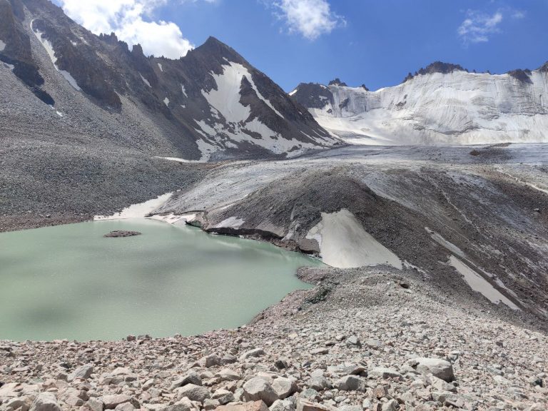
On July 21, the ISOC research team embarked on an expedition to Adygene Glacier Mountain Lake, strategically situated 60 km south-southwest of Bishkek. Nestled at an altitude of 3600m in the upper reaches of the Adygene river valley, a left-side tributary of the Ala-Archa river, this high glacier lake serves as a focal point for the deployment of IoT sensors aimed at monitoring glacial lake outburst floods.

The Adygene lake complex, positioned on the sea of the glacier, encompasses three additional lakes to the south and southeast. The southeasternmost lake, situated at an elevation of 3640 meters, was formed along the northern edge of the glacier, with its southern coast adjoined to the glacier itself. Measuring 188 meters in length and 70 meters at its widest point, the lake has a perimeter of 550 meters, covering an area of 17142 square meters. A stream flows from the northeastern side, eventually merging with a small moraine lake after a 330-meter journey. Additionally, the southern part of the lake houses ten more small moraine lakes.

Under the guidance of our partner, the Institute of Water Problems under the Academy of Sciences of the Kyrgyz Republic, Adygene glacier lake has been subject to monitoring using various technological means. The Adygene station, established in 2008, plays a pivotal role in studying high mountain lakes and glaciers while safeguarding the local population from potential outbursts. Adjacent to the station, a traditional meteorological station has been set up, where researchers manually collect daily data using sensors and retrieve information from an automatic station.

Initially, geostationary connectivity was employed due to the absence of mobile coverage. However, owing to budgetary constraints, this option was abandoned, given the exorbitant monthly costs ranging from 200 to 500 USD.

Recognizing the line of sight with Chuy valley base stations, the Research team of ISOC Kyrgyz Chapter and ICTP proposed the implementation of LoRaWAN connectivity, offering real-time 24/7 monitoring at a more affordable 3-dollar GSM connectivity monthly plan.

With this strategic rationale, the ISOC Kyrgyz Chapter members and interns from the Institute of Water Problems embarked on a strenuous six-hour hike to the location. The journey was characterized by challenging terrain, transitioning from hot summer conditions to rainy and windy weather, accompanied by temperature fluctuations of up to 20 degrees.

Upon reaching the destination, the team meticulously assessed connectivity, identified potential spots for setting up communication gateways, determined the types of measurements and sensors required, and outlined the necessary mast installations. Following an intense day, the team returned to the main road of Ala-Archa national park late at night. Armed with the collected data, a comprehensive working and logistics plan was formulated for the installation of the Internet of Things infrastructure at Adygene Glacier Lake.

Биз LoRaWan тармагын жана сенсорлорду үзгүлтүксүз тейлөөнү камсыз кылабыз

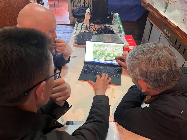
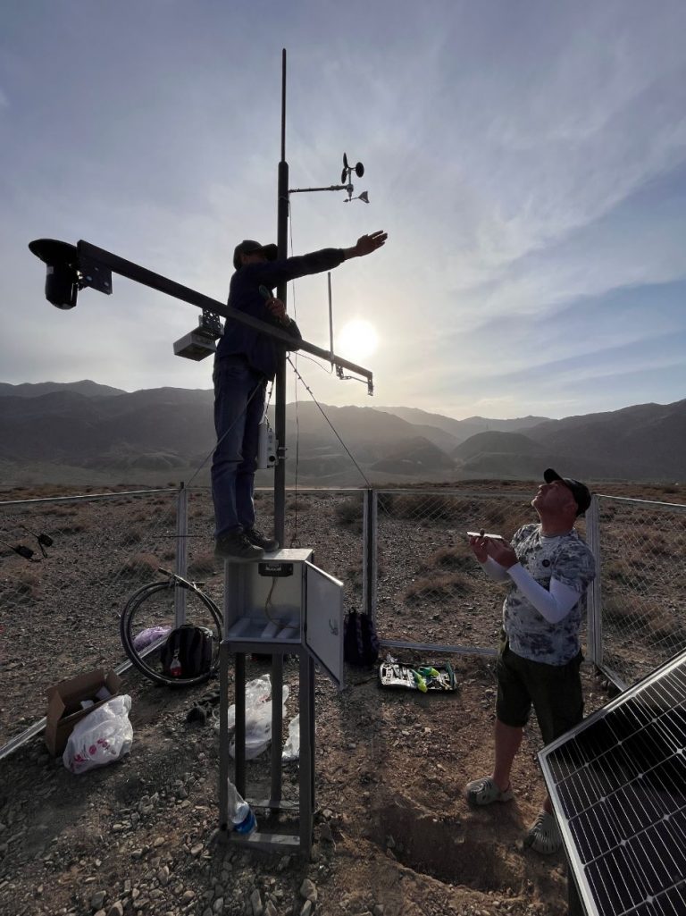
The ISOC Kyrgyz Chapter team has been actively engaging in routine maintenance visits to our pilot locations. Since the initial installation of LoRa-enabled sensors, certain units have necessitated additional on-site attention to ensure optimal performance.

In some instances, ensuring the proper functioning of sensors called for tasks such as excavation from the soil, recalibration, and subsequent reburial. In other cases, the effective operation of sensors demanded the application of specific, albeit previously undocumented, installation techniques. Additionally, challenges arose in certain cases due to inconsistent sensor quality from specific vendors.

To address these complexities, interns from the Institute of Water Problems were actively involved in the process. Their participation served a dual purpose – to offer hands-on training and education and to facilitate the exchange of expertise with students.

As we continue to progress through the data collection stage of our research project, these maintenance efforts remain instrumental in ensuring the accuracy and reliability of our LoRa-enabled sensors in diverse environmental conditions.

LoraWan IoT Data Dashboard

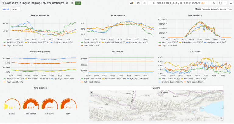
The team created beta version of the dashboard visualization of the project data collected from pilot locations.

The dashboard represents visualization of the following data: relative air humidity, air temperature, solar irradiation, atmospheric pressure, precipitation, wind speed, wind direction. The other dashboard represents visualization of the following data: soil moisture and precipitation, water level. Dashboards are available in Kyrgyz, English and Russian languages. Some dashboards are specially designed for local communities to use for the benefit of community.

We believe in open source solutions. That’s why we use Grafana – a multi-platform open source analytics and interactive visualization web application.The information gathered from Lora-enabled sensors through Lorawan communication gateways and transmitted to the central server via GSM network. Collected IoT telemetry data stored on servers and then visualized using Grafana software. Up-to date information is available via link: http://dashboard.isoc.kg

Note. Since its scientific project, some publicly available data may have wrong parameters or data due to internal experiments, settings, tuning, etc. Please consult before use in research purposes.

ISOC Кыргыз бөлүмү жана Суу проблемалары институту бийик тоолуу мөңгүлөрдүн көлдөрүнө мониторинг жүргүзүү үчүн кызматташат

19 мая 2023 года Кыргызское отделение Интернет-общества (ISOC) провело встречу с Институтом водных проблем Академии наук Кыргызской Республики. Обсуждение вращалось вокруг текущего состояния мониторинга высокогорных ледниковых озер, потенциальных преимуществ проекта ISOC для кыргызских ученых и предстоящих планов по установке датчиков.

Мониторинг высокогорных ледниковых озер имеет огромное значение, учитывая их значительную роль в поддержании местного и регионального водного баланса. Однако такие проблемы, как удаленность, суровые условия окружающей среды и технические ограничения, часто затрудняют комплексный мониторинг. В ходе встречи представители кыргызского отделения ISOC представили свой текущий исследовательский проект, направленный на преодоление этих препятствий за счет инновационного использования технологий.

В рамках проекта исследовательских грантов, финансируемого Фондом ISOC, кыргызское отделение ISOC планирует установить метеорологические станции, датчики измерения уровня снега и воды на ледниковом озере Адыгене и прилегающих моренах. В этом проекте будут использоваться передовые датчики с поддержкой Lorawan для предоставления данных в режиме реального времени о различных параметрах окружающей среды. С помощью этой инициативы Отделение стремится поддержать существующие усилия по мониторингу, предоставляя надежный и последовательный поток данных, который может помочь ученым в понимании и более точном прогнозировании поведения ледников.

Участники встречи обсудили возможные даты установки датчиков, сузив их до периода с июня по июль 2023 года. Этот график согласуется с оптимальными погодными условиями для таких операций, что обеспечивает более безопасные и эффективные процедуры установки.

Институт водных проблем, ведущий орган по исследованиям в области водных ресурсов в Кыргызстане, выразил высокую поддержку исследовательской работе кыргызского отделения ISOC. Институт высоко оценил технический подход к решению задач мониторинга ледников и выразил оптимизм по поводу положительных результатов этого исследовательского проекта. Сотрудничество знаменует собой значительный шаг к обогащению научного ландшафта Кыргызстана за счет сочетания традиционных полевых исследований с передовыми технологиями.

По мере реализации проекта он будет способствовать более глубокому пониманию динамики ледниковых озер. Что еще более важно, он предоставит полезную информацию для управления водными ресурсами, прогнозирования бедствий и усилий по смягчению последствий изменения климата, тем самым подчеркнув преобразующую роль технологий в сохранении окружающей среды.

Installing Automatic Weather Stations and Sensors for Local Monitoring in the Boom Gorge

The ISOC Kyrgyz Chapter team, in response to a request from the Ministry of Emergency Situations, has made a crucial advancement in natural disaster mitigation and management. From May 7 to May 17, 2023, the team installed two Lorawan-enabled meteostations and additional sensors in the Boom Gorge of the Kyrgyz Republic. This vital initiative aims to enhance the understanding and monitoring of the region’s distinct microclimate, providing key data to inform preemptive action and disaster management.

The Boom Gorge, marked by unique orographic features and a complex geological structure, has historically grappled with the impacts of heavy rainfalls. These intense precipitations often trigger powerful mudflows, draining from side valleys onto railroads and roads, causing significant infrastructural damage and posing public safety risks. Given the challenges posed by climate change, obtaining accurate and reliable local environmental and meteorological data in this region is becoming increasingly crucial.

In a pioneering research project, the Internet Society Kyrgyzstan Chapter, in collaboration with the Abdus Salam International Centre for Theoretical Physics and the Ministry of Emergency Situations, has been exploring the utility of data transmission using the LoRaWAN protocol in areas susceptible to hazardous natural processes and with limited cellular communications. As part of this research project, two automatic weather stations have been installed in the Boom Gorge, along with additional sensors at key locations: Kyz-Kuye and Kok-Moinok. These locations mark the entry and exit points of the gorge, respectively.

The primary aim of this project at these pilot sites is to monitor and evaluate key meteorological parameters, including precipitation, temperature, moisture, and soil temperature. By doing so, the researchers aim to deepen their understanding of these parameters’ influence on the formation of mudflows in the Boom Gorge.

This installation of automatic weather stations and additional sensors is expected to considerably enhance the accuracy and systematic assessment of meteorological parameters. The use of the LoRaWAN data protocol technology enables continuous monitoring, providing more accurate and up-to-date data while reducing connection operating costs. This invaluable data will underpin informed decisions about mudflow risks and mitigation strategies.

Moreover, the placement of these local weather stations and sensors will facilitate comprehensive studies on the influence of meteorological parameters on mudflow formation processes. In the future, the data collected will enable the Department for Monitoring and Forecasting Natural Disasters of the Ministry of Emergency Situations to determine the threshold values needed to build a high-quality temporal forecast of mudflow events in the Boom Gorge.

Through this blend of technology and scientific research, we aim to deepen our understanding of mudflow dynamics and develop effective measures to mitigate their adverse impacts on infrastructure and people’s lives. The ISOC Kyrgyz Chapter and the Department of Monitoring and Disaster Forecasting are proud to contribute to this vital research project, fostering a safer and more sustainable future for the region.

The Internet Society Foundation’s research grant program funds this pioneering project, with the implementation by the Internet Society Kyrgyz Chapter Public Association and the Abdus Salam International Centre for Theoretical Physics.